Imagine stepping out your door and onto a riverside path within minutes. In East Aspen, you get the quiet of open space with everyday access to trails, water, and views. You also share that setting with visitors, seasonal events, and a unique set of rules that shape what you can build or change. This guide breaks down the lifestyle upsides, the tradeoffs, and the due diligence steps that help you choose the right property with confidence. Let’s dive in.
Why East Aspen’s trails matter
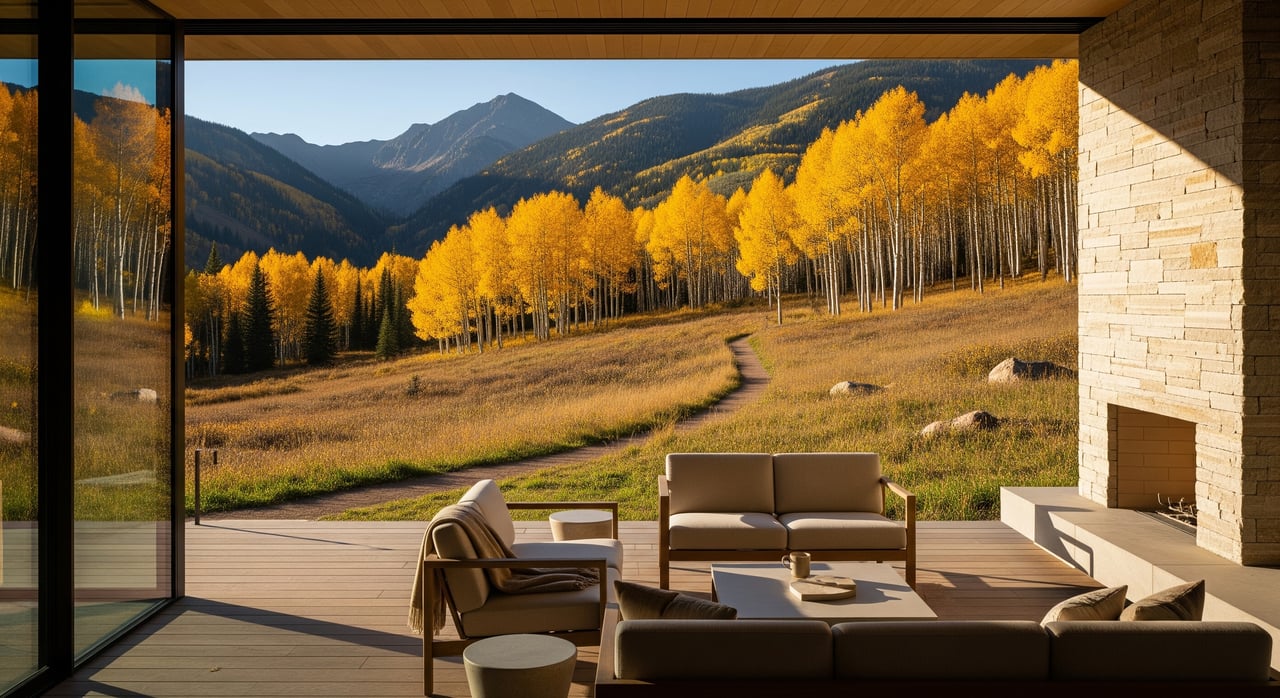
Living east of downtown Aspen puts you along the Roaring Fork River corridor, where paved multi-use routes, natural singletrack, and open-space parcels create a true outdoor lifestyle. You can walk, bike, or run from your door and enjoy a natural buffer from nearby homes. Many buyers value the calm, the views, and the ability to recreate without driving.
At the same time, these assets attract day-users. In peak seasons, you should expect more people on the paths, early-morning activity, and occasional parking pressure near trail access points. Understanding these rhythms helps you pick a micro-location that fits your privacy and access goals.
Who manages what nearby
Multiple organizations oversee the trails, river access, and open space east of town. Knowing who manages the parcel or corridor next to you helps you understand rules today and projects coming tomorrow.
- City of Aspen manages in-city open space, some in-town trails, urban riparian areas, and municipal land-use rules and utilities.
- Pitkin County Open Space & Trails acquires and manages larger open-space parcels, implements conservation easements, and oversees trail corridors, including portions of the Rio Grande Trail.
- Roaring Fork Conservancy focuses on river health, water quality, and access guidance along the Roaring Fork River.
- U.S. Forest Service (White River National Forest) manages trailheads and backcountry access in the surrounding mountains.
- Colorado Parks & Wildlife sets fishing regulations, wildlife management, and seasonal restrictions that can affect trail use.
- FEMA and local floodplain administrators set flood zone designations and building requirements for river-adjacent parcels.
Bottom line: different managers set different rules on activities, closures, allowable improvements, and maintenance. Identify the specific parcel or trail segment beside your property and confirm the governing agency.
Trail types and river access
East Aspen offers a mix of connected routes and natural areas.
- Paved multi-use trails support walking, biking, commuting, and strollers.
- Gravel service roads and natural-surface singletrack cater to hikers, runners, and mountain bikers.
- In some winters, select routes are groomed for fat biking, nordic use, or snowshoeing, depending on agency plans and conditions.
The Roaring Fork River provides scenic corridors and fishing access at designated points. Much of the riparian zone is conserved, with setbacks that limit new shoreline structures or access improvements. Seasonal flows matter. Spring runoff raises water levels and can make banks unsafe or reduce access until flows subside.
Micro-location tradeoffs to weigh
The same features that make East Aspen special can create day-to-day tradeoffs. Clarify your priorities before you buy.
- Privacy vs. access: Immediate trail frontage brings convenience and views but also more passersby and early activity.
- Paved vs. singletrack adjacency: Paved corridors see broader use by commuters and families; low-use singletrack may feel quieter.
- Summer vs. winter: Summer has the heaviest traffic due to tourism and events. Winter usage can be lower in the valley, but groomed routes draw users.
- Parking and trailheads: Homes close to access points may experience more on-street parking and short-term noise when people arrive early.
- Event impacts: Special events and festivals can increase traffic and trail use for short windows.
River adjacency: flood, erosion, and insurance
If you are near the river, plan for additional checks and potential requirements.
- Flood zones: FEMA designations and local floodplain ordinances can require elevated building standards and can affect insurance costs.
- Riparian setbacks: City and county rules often limit how close you can build to the riverbank and what improvements are allowed.
- Erosion and channel migration: Over time, bank stability can change, which affects long-term planning and risk.
Confirm current flood maps, local ordinances, and any site-specific conditions before you commit to a remodel or addition.
Open space, easements, and property value
In general, proximity to maintained trails and open space tends to increase desirability and can support premium pricing. That said, the effect is parcel-specific. Views, privacy, and the type of trail frontage matter. Open space and conservation easements protect what you see, but they can also limit what you can build, expand, or modify.
If a property includes a conservation or trail easement, read the recorded instrument carefully. Some easements limit subdivision, define building envelopes, or restrict exterior changes and landscaping.
Second-home and rental realities
If you plan to use the property seasonally or as a rental, take a closer look at management and regulations.
- Short-term rental rules: The City of Aspen and Pitkin County have frameworks that govern licensing, limits, taxes, and occupancy. Regulations change over time, so verify current rules before assuming rental income.
- Property management: Plan for snow removal, guest parking, trash service, and routine checks when the home is unoccupied.
- Maintenance clarity: Public agencies maintain public trails, but responsibilities for private access, shoulder clearance, or informal connections vary. Ask for maintenance agreements or records when available.
Services and utilities snapshot
Service boundaries influence cost and convenience.
- Inside city limits: Municipal water and sewer are typical, along with city snow removal on public streets.
- Outside city limits: Some parcels rely on private wells or septic and county services.
Confirm utilities and service providers early. Utility availability can shape renovation feasibility and long-term operating costs.
A practical due diligence checklist
Use this list to structure your property review and reduce surprises after closing.
Property-level checks
- FEMA flood maps and local floodplain designation, including base flood elevation and insurance implications.
- Recorded conservation, trail, or access easements, plus right-of-way encumbrances shown in the title report.
- City or county setbacks and riparian buffer requirements from the applicable code.
- Parcel map and topography for slope stability, erosion potential, soil, and riverbank proximity.
- Zoning, permitted uses, building envelope limits, and any overlay zones (historic or scenic).
- Agreements for shared drives, on-street parking, or private trail connections.
Neighborhood and lifestyle checks
- Identify the managing agency for adjacent trails and confirm whether the corridor is paved multi-use or natural singletrack.
- Observe parking dynamics near access points and whether there is a neighborhood permit program or enforcement.
- Review seasonal event calendars that might route along nearby valleys or corridors.
- Confirm who clears sidewalks and streets in winter and how snow storage affects access.
Regulatory and ecological checks
- Current short-term rental and second-home rules at the city or county level.
- Wildlife corridors and any seasonal closures or leash rules posted by local managers.
- Water-rights implications if the parcel uses ditches or private diversions.
Practical site visits
- Visit early morning, midday, and evening in different seasons to experience trail traffic, river flows, and ambient noise.
- Walk the property boundaries and nearby open-space parcels to confirm access points and bank conditions.
- Talk with neighbors or local property managers to understand patterns like parking overflow, trespass, or wildlife.
How to choose the right spot
Start by ranking what matters most to you: immediate access, privacy, views, or expansion potential. Next, map the managing agency for the adjacent trail or parcel and note any planned projects. Compare river-adjacent options to interior lots that still access trails without direct frontage.
If you plan a remodel or new build, align your vision with floodplain and riparian requirements from the start. The right plan preserves what you love about the setting without overstepping local rules.
How Team Hansen helps you buy with clarity
You deserve clear answers before you invest. As Aspen natives with construction-informed insight, we help you understand the tradeoffs between a paved corridor lot and a quieter singletrack edge, translate conservation and trail easements, and coordinate early conversations with city or county planners. If rental use is part of your plan, we provide seasonal rental placement and leasing/management support, and we help set a practical operating plan for snow, trash, and guest parking.
Whether you are buying a primary home or a second home, our goal is to match you with the right micro-location and a clear path to ownership, renovation, or rental success. When you are ready, reach out to Team Hansen for a private consultation or property tour.
FAQs
What is it like to live near East Aspen trails and open space?
- You get immediate access to paved and natural-surface routes with scenic buffers, along with seasonal peaks in user activity, parking near access points, and occasional event-related spikes.
How close to the Roaring Fork River can you build in East Aspen?
- Local riparian setbacks and floodplain rules apply, and river-adjacent parcels may need elevated building standards; confirm specific setbacks and FEMA designations before planning work.
Are short-term rentals allowed near East Aspen’s open space?
- The City of Aspen and Pitkin County regulate short-term rentals with licensing, limits, taxes, and occupancy rules that can change; verify current requirements for your exact address.
How busy do East Aspen trails get by season?
- Summer sees the heaviest use from commuters and visitors, while winter volume is lower in many valley areas, with activity concentrated where routes are groomed.
Who maintains the trails and access near East Aspen homes?
- Public trails are typically maintained by the managing agency, such as the City of Aspen or Pitkin County Open Space & Trails; private easements or informal access points may involve different responsibilities.